Districts & Subdivisions - Case Briefings
Districts & Subdivisions Strategy #2 | Infill Incentive Districts
For this strategy, communities should seek to designate an infill district or district areas that allow for a mix of land uses that prioritize infill development, including attainable and affordable housing. One of the first steps in implementing this approach is for a community to evaluate infill district locations and intended goals. As part of the overall policy or program setup, local decision makers will need to review and understand what monetary incentives they are comfortable with and able to provide, considering their impact on existing infrastructure. Approaches to this strategy may include a combination of the following: reimbursing or reducing taxes, reducing, or eliminating certain application, processing, or impact fees, or other locally designated incentives to promote affordable housing in infill districts. Implementation benefits might include reduced development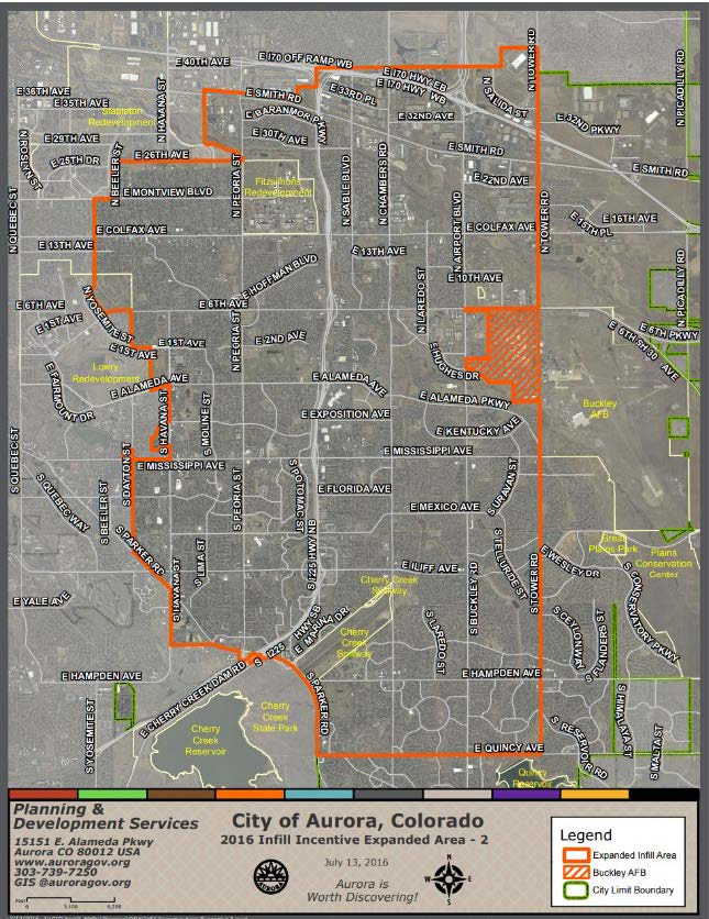 costs, an increase to the tax base from under-utilized properties, and maximizing investments in existing infrastructure and ongoing maintenance. Residents may benefit from this strategy through infill development near existing services and integration with existing neighborhoods. This strategy also encourages new development within areas with existing infrastructure, promoting viable open space and preservation of prime agricultural lands within, and surrounding communities.
Community Example
Infill Development Incentive Program, City of Aurora, Colorado
In 2016, the City of Aurora developed an infill incentive program for a large area of the city running along I-225, south of I-70. This program offers a 50 percent reduction on development fees up to a maximum of $25,000 per project. The program does exclude water impact fees, as is the case with most local government incentive programs throughout the state. The program is funded through a limited time, with extensions granted by Council from time to time, based on available funds. There are specific program qualifying criteria that includes maximum commercial square footage and total number of residential units. Additional program criteria can be found through the project link below.
Source: Infill Development Incentive Program
Districts & Subdivision Strategy #3 | Mixed-Use Zoning District (Rural Adaptation)
The purpose of this strategy is to establish flexible, by-right, mixed-use zoning districts adjacent to town centers and in targeted growth areas to accommodate new development opportunities for affordable and attainable housing, following the communities comprehensive plan goals. The first step is to determine appropriate locations using comprehensive plans and other supportive documents, and through community engagement. Next communities should identify the types of uses for their mixed-use districts, as well as appropriate density levels through vertical or horizontal mixed-use development patterns. Finally, communities adopt new or modified zoning regulations that are respectful to the local community context and built environment characteristics. Benefits of this strategy may include an appropriate mix of land uses that are financially resilient and flexible to accommodate new business and residential development patterns as market conditions evolve. Additionally, businesses benefit from having ‘built-in’ clients that may live above or within close proximity to their establishments. Residents may benefit from vibrant service centers, unique community character areas, enhanced main streets, and living in close proximity to daily service needs. This approach also promotes walkability, activates vacant or under-utilized upper floors in traditional downtown areas, and creates a sense of place and activity for the community.
Community Example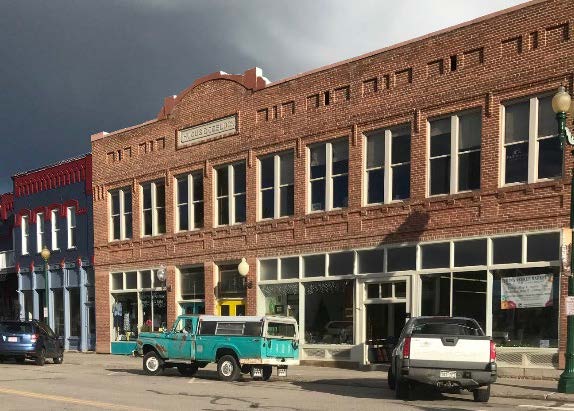
Zoning Regulation Changes, Meeker, Colorado
In 2023, Meeker worked to update their local zoning regulations to promote a variety of community goals, including efforts to foster new affordable and attainable housing units within the community. Their zoning regulations were updated to match the community vision and need for additional residential options within or near the historic town core area. The resulting changes allowed for higher residential densities in the historic downtown area and the removal of barriers to the redevelopment and activation of upper floor residential units. It is anticipated that this effort will improve accessibility for residents to nearby businesses and support services and create more ‘built-in’ clients for current and future businesses.
Source: Meeker Zoning Regulations and Meeker website
Districts & Subdivisions Strategy #4 | Cluster / Conservation Subdivisions (Rural Adaptation)
The purpose of this strategy is to establish requirements for developments to cluster residential lots on lots smaller than what would otherwise be allowed by the base zone district to preserve open and rural character areas that may include natural areas, open spaces, and/or prime agricultural lands. Typically, these preserved and undivided areas would make up at least half of the total site area. To implement this strategy, communities work to identify minimum lot sizes and establish conservation goals to create new zone districts or overlay development criteria for areas around a community’s edge and growth area. Key benefits to this strategy are that it offers opportunities to maximize density and units within a concentrated area, it reduces infrastructure installation and maintenance costs, and it accommodates new homes and housing types that create more choice and opportunity including affordable and attainable housing. Additional benefits to residents include enhanced community and neighborhood character and enabling a logical and well-thought-out transition to rural areas, open spaces, and farmlands. Environmental benefits include potential land conservation, increasing open space opportunities, and preserving key habitat areas and prime agricultural lands.
Community Example
Conservation Development Criteria, Larimer County, Colorado
Larimer County’s Land Use Code (adopted 2021) placed an emphasis on the protection of natural and agricultural areas located adjacent to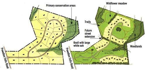 communities and within rural development pockets throughout the County. Clustering and conservation development criteria was established to promote the preservation of natural and agricultural areas by allowing higher levels of density and variety in residential lot sizes and product types in areas designated as cluster and conservation overlay areas.
As part of their efforts, the County created helpful guides for an applicant to understand the purpose, process, and review criteria when considering a conservation development within the County. This is a useful tool to promote and move the needle towards implementation within the County and rural development areas located outside of and/or adjacent to incorporated municipal boundaries. The guide can be found online and by visiting the County’s Planning webpage linked below.
Source: Larimer County Website